Understanding Microbursts: Destructive Downdrafts Explained
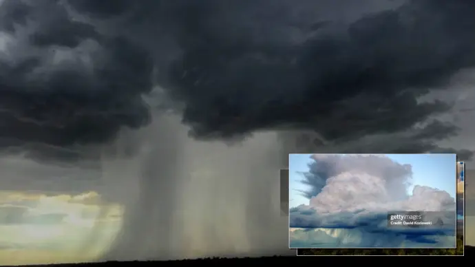
A microburst is a terrifyingly powerful, localized downdraft within a thunderstorm. These intense columns of sinking air can unleash destructive winds at ground level, often mistaken for tornadoes. Understanding what a microburst is, how it forms, and its potential impact is crucial for safety and preparedness.
Key Microburst Facts
- Definition: A concentrated downdraft within a thunderstorm, typically 2.5 miles in diameter or smaller.
- Damage Potential: Can produce winds up to 100 mph, causing significant structural damage and felling trees.
- Identification: Often mistaken for tornadoes, but microbursts produce straight-line winds, not rotating ones.
- Forecasting: Predicted on a near-term basis (6-12 hours) using specific atmospheric parameters.
What Exactly Is a Microburst?
A microburst is defined as a localized column of sinking air, also known as a downdraft, that originates within a thunderstorm. These phenomena are generally no larger than 2.5 miles in diameter. While their size might seem small, the impact at the surface can be extensive and, in some severe cases, life-threatening. There are two primary types: wet microbursts, accompanied by significant precipitation, and dry microbursts, which occur with little to no rain at the surface.
The Formation Process of Microbursts
The genesis of a microburst is intrinsically linked to the development of a thunderstorm. Within the storm, updrafts carry water droplets and hailstones upward. In some instances, these updrafts become exceptionally strong, suspending large quantities of precipitation high in the storm cloud. Several atmospheric factors can then lead to evaporational cooling. As precipitation falls and evaporates in the mid-levels of the storm, it cools the surrounding air. This cooler, denser air sinks rapidly, creating a powerful downdraft. When this downdraft, often carrying a heavy core of rain or hail, weakens the storm's updraft, it can no longer be supported. The core then plummets toward the ground.
Upon impact with the surface, this descending air mass spreads out dramatically in all directions. The point where the microburst first strikes the ground experiences the most intense winds and consequently, the greatest damage. This process is critical to understanding the microburst meaning beyond just a strong wind event.
Microburst Damage and Wind Intensity
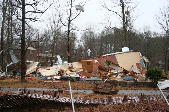
The wind speeds generated by a microburst can be astonishingly high, reaching up to 100 mph or even exceeding this, which is comparable to an EF-1 tornado. Such wind speeds are capable of causing severe damage to homes and other structures, and can easily level hundreds of trees. It is imperative to treat Severe Thunderstorm Warnings with the same seriousness as Tornado Warnings, given the destructive potential of microbursts. The damage from these straight-line winds can appear widespread and catastrophic.
Forecasting Microburst Potential
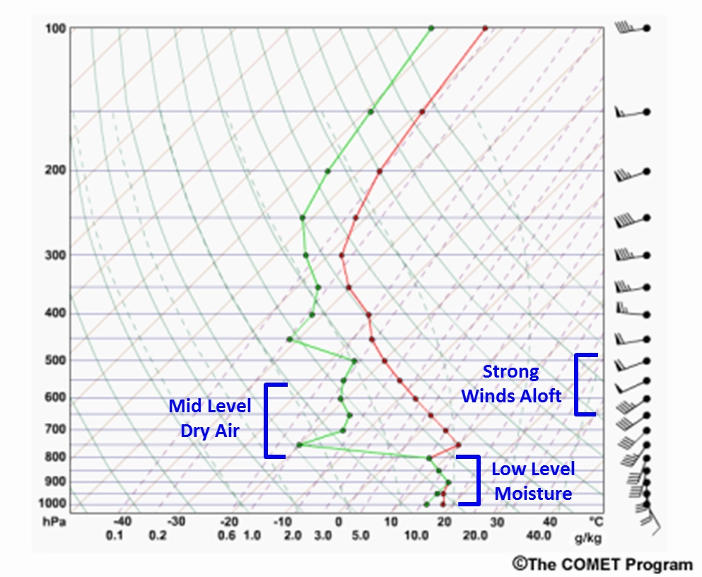
Forecasting the likelihood of microbursts is typically conducted on a short-term basis, usually within a 6 to 12-hour window before expected convection. Meteorologists analyze several atmospheric parameters to assess this potential, particularly during the warmer months. Key ingredients include atmospheric instability, high precipitable water content, the presence of dry air in the mid-levels of the atmosphere, and strong winds within that dry layer. These conditions often coalesce during hot, humid summer afternoons, especially in regions like the Southeastern United States.
Warning and Detection Challenges
Detecting and issuing timely warnings for microbursts presents significant challenges. When analyzing radar data, forecasters look for specific signatures, such as a mid-altitude radial convergence (MARC) signature, which indicates converging air within the thunderstorm's mid-levels. However, microbursts are notoriously short-lived and can sometimes occur between radar scans, making them difficult to detect precisely. Consequently, the lead time for Severe Thunderstorm Warnings related to microbursts can be very short, or in some cases, there may be no warning issued at all. Ongoing research and advancements in radar technology continue to improve our understanding and detection capabilities, hopefully leading to better warning lead times in the future.

Once a microburst reaches the ground, a distinct divergence signature becomes visible on radar. This signature shows winds rapidly spreading outward from the point of impact. The visual representation on Doppler radar clearly distinguishes between winds blowing towards the radar (indicated by green) and those blowing away from it (indicated by red), highlighting the divergent outflow characteristic of a microburst.
Microbursts vs. Tornadoes: A Clear Distinction
It is vital to differentiate microbursts from tornadoes. While both phenomena involve strong winds and can cause similar levels of destruction, their fundamental nature differs. A tornado is characterized by rotating columns of air that extend from the base of a thunderstorm to the ground. In contrast, a microburst is a straight-line wind event caused by a rapidly descending and then outward-spreading column of air. This distinction is why damage from a microburst is often described as straight-line wind damage, not tornado damage.
Real-World Impact: Philadelphia Storms
Recent events in the Philadelphia region, specifically in Lower Merion and parts of West Philadelphia, provide a stark example of microburst impacts. Following weekend storms, utility crews and city workers were engaged in restoring power and clearing numerous downed trees. Officials reported that the winds, estimated between 60 to 70 mph, caused considerable vehicle and utility damage, though fortunately, no injuries were reported. The National Weather Service confirmed that the damage was attributed to straight-line winds from several severe microbursts, underscoring their significant destructive power even without rotation.

Atmospheric Conditions Favoring Microbursts
The development of microbursts, particularly dry microbursts, is often associated with specific atmospheric conditions prevalent during the summer months. Key factors include significant atmospheric instability, which provides the energy for strong updrafts and downdrafts. High precipitable water content indicates a large amount of moisture available in the atmosphere that can contribute to downdraft development through evaporational cooling. The presence of dry air in the mid-levels is crucial, as it enhances the cooling effect when precipitation evaporates. Finally, strong winds in this dry layer help to accelerate the sinking air. These conditions are frequently met during hot and humid summer afternoons in certain geographical areas.
Staying Safe During Severe Weather
Given the unpredictable nature and rapid onset of microbursts, preparedness is key. Always take Severe Thunderstorm Warnings seriously. If you are outdoors when a microburst is imminent or occurring, seek substantial shelter immediately. Avoid areas prone to flooding and stay away from windows. While specific forecasting for microbursts is challenging, understanding the general conditions that favor severe thunderstorms can help in anticipating potential risks. Continued research into microburst phenomena, including the study of microburst learning curves in weather modeling, aims to improve our ability to predict and warn the public effectively. Whether in Arizona, Texas, or other regions prone to convective storms, staying informed is the best defense.
Conclusion: Preparedness is Key
Microbursts represent a significant meteorological hazard, capable of inflicting damage equivalent to tornadoes. Their formation, driven by complex thunderstorm dynamics and atmospheric conditions, makes them challenging to forecast with long lead times. Differentiating them from tornadoes based on their straight-line wind patterns is crucial for accurate damage assessment and public safety messaging. By understanding the science behind these powerful downdrafts and heeding severe weather warnings, individuals can better prepare for and mitigate the risks associated with microburst events. Stay informed about weather patterns, especially during summer months, and always prioritize safety when severe weather threatens.
Comments (0)
No comments yet. Be the first to share your thoughts!
Leave a Reply
Your email address will not be published. Required fields are marked *