Understanding Extratropical Cyclones: Formation, Characteristics, and Differences
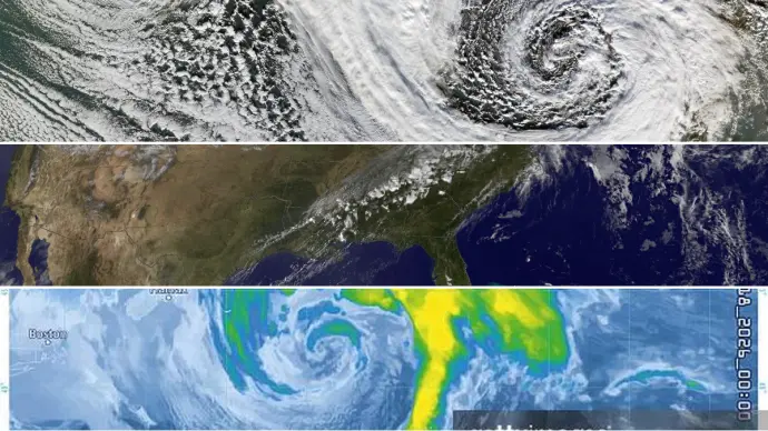
It is often challenging to determine from forecast model data whether a low-pressure system developing near the U.S. coast will be tropical, subtropical, or extratropical. This distinction is crucial because tropical systems possess the potential to rapidly evolve into hurricanes, a capability not shared by extratropical or subtropical storms. This guide provides a concise meteorological lesson on the typical progression observed from extratropical cyclones to subtropical cyclones and finally to tropical cyclones.
Key Takeaways on Extratropical Cyclones
- Formation: Extratropical cyclones form from the interaction of cold and warm air masses, deriving energy from potential energy release. They are associated with fronts and can occur over land or sea.
- Characteristics: Unlike tropical cyclones, they have a cold core and are linked to weather fronts.
- Wind Speeds: Their wind speeds can range from those of a tropical depression to a hurricane.
- Examples: Common examples include blizzards, Nor'easters, and typical mid-latitude low-pressure systems.
The Formation and Characteristics of Extratropical Cyclones
An extratropical cyclone begins to form when cold air is present at its core. These storms derive their energy from the release of potential energy that occurs when cold and warm air masses interact. A defining feature of extratropical cyclones is the presence of one or more associated weather fronts. These systems can develop over both land and ocean surfaces.
The wind speeds within an extratropical cyclone can vary significantly, ranging from as weak as those found in a tropical depression to as strong as those characteristic of a hurricane. Common examples of extratropical cyclones include phenomena such as blizzards, Nor'easters, and the ordinary low-pressure systems that are responsible for delivering much of the precipitation to continents in the mid-latitudes.
Progression to Subtropical and Tropical Cyclones
If an extratropical cyclone forms over waters that are at least 21 degrees Celsius (70 degrees Fahrenheit), thunderstorm activity can gradually develop within the storm. This process moistens and warms the lower levels of the atmosphere. Over time, the core of the storm may transition from cold to warm. At this stage, the storm begins to draw energy from "latent heat." Latent heat is released when water vapor, which has evaporated from warm ocean waters, condenses into liquid water. This latent heat is the primary energy source for tropical cyclones.
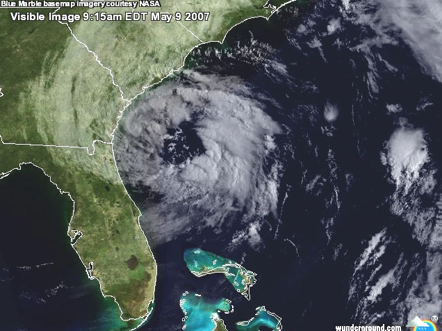
When a storm begins to utilize latent heat, it is classified as subtropical. If the sustained winds in such a storm exceed 39 miles per hour, it is designated as a subtropical storm. This occurred with Subtropical Storm Andrea in 2007. If the winds are below 39 miles per hour, it is termed a subtropical depression. It is important to note that a subtropical depression does not necessarily precede the formation of a subtropical storm; one can develop directly.
Distinguishing Subtropical Storms
A subtropical storm typically exhibits a large, cloud-free center of circulation. Intense thunderstorm activity is usually concentrated in a band located at least 100 miles from the center. While the wind intensity a subtropical storm can generate is comparable to a tropical storm, tropical storms tend to produce more rainfall. There is no classification of a "subtropical hurricane." If a subtropical storm intensifies to the point of having hurricane-force winds, it is considered to have become fully tropical.
According to the National Hurricane Center, the definition of a subtropical storm is a non-frontal low-pressure system possessing characteristics of both tropical and extratropical cyclones. The most common type involves an upper-level cold low with a surface-level circulation. Its maximum sustained winds typically occur at a radius of about 100 miles or more from the center. Compared to tropical cyclones, these systems have a broader zone of maximum winds located farther from the center, often with a less symmetric distribution of wind and convection.
A second type of subtropical cyclone originates as a mesoscale low within or near a zone of horizontal wind shear, where a front is dissipating. In this case, the radius of maximum sustained winds is generally less than 30 miles, and the entire circulation may have a diameter of less than 100 miles. These systems are typically short-lived and can be either cold-core or warm-core.
Tropical vs. Extratropical Cyclones: Data and Observations
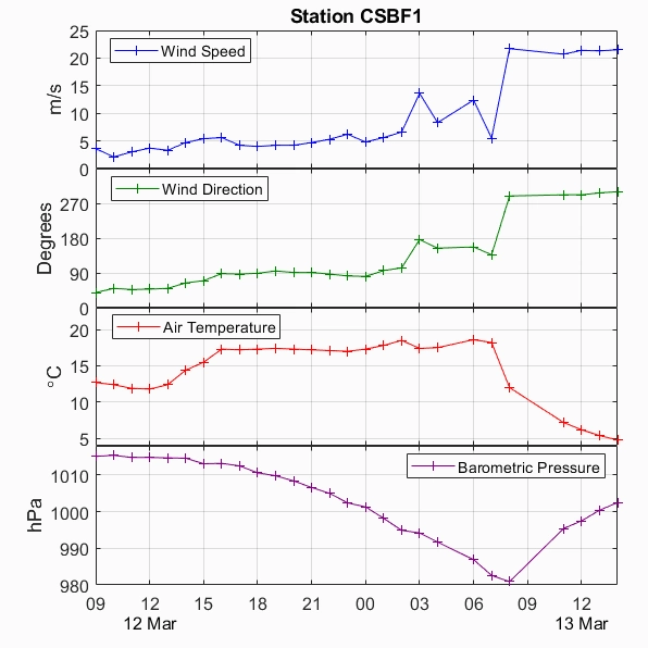
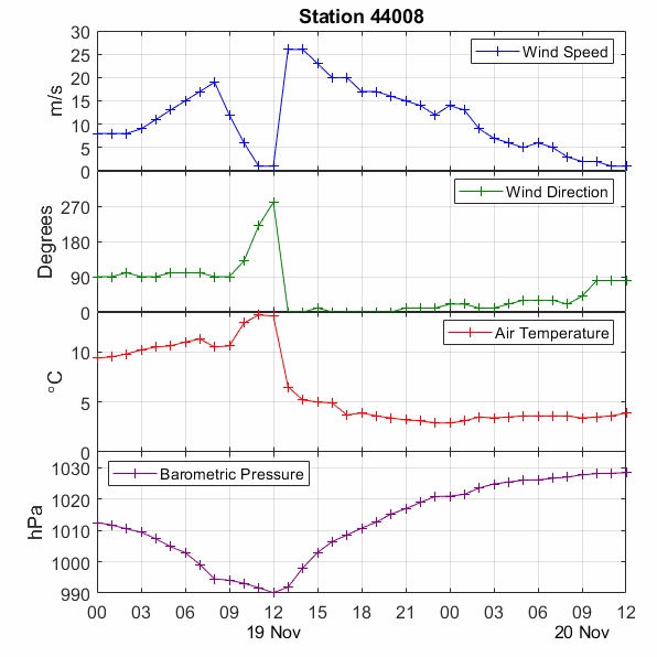
Tropical and extratropical cyclones present different data traces as they move past weather monitoring stations. Tropical cyclones are synonymous with hurricanes and tropical storms, while extratropical cyclones encompass winter storms and typical low-pressure areas. Analyzing time-series plots can help differentiate between these storm types.
For instance, measurements taken during Hurricane Hugo, a tropical cyclone, at Folly Beach, South Carolina, showed an abrupt, significant drop in pressure over a few hours, followed by a symmetrical rise. The data also indicated a distinct one-hour lull in winds near the eye, flanked by sharp peaks marking the eyewall. Tropical systems are often smaller than extratropical ones and lack evidence of fronts.
The air temperature during Hurricane Hugo remained consistently between 24 to 26 degrees Celsius, with wind directions showing a prolonged period from the Northeast before the eye's passage and from the Southwest afterward. This consistency in temperature and directional wind shifts is characteristic of tropical systems.
The March 1993 Superstorm: An Extratropical Example
In contrast, consider the time-series plots for the March 1993 Superstorm, also known as "The Storm of the Century." This event was a powerful extratropical or winter storm. Unlike tropical cyclones, its data would reveal different characteristics, reflecting its extratropical nature.
Understanding the extratropical cyclone characteristics is vital for accurate weather forecasting and public safety. The formation process, involving the interaction of air masses and the role of fronts, clearly distinguishes them from the warm-water fueled tropical cyclones. The distinct energy sources and structural differences lead to varied impacts and behaviors, making the identification of extratropical cyclone stages important for meteorologists.
Comments (1)
Alex Johnson
17:41:39 21-07-2026Leave a Reply
Your email address will not be published. Required fields are marked *